.webp)
Fire Weather Watch Escalates as Critical Conditions Threaten the US
Introduction
An invisible transformation of the American landscape is placing millions of residents on high alert as atmospheric conditions shift into a dangerous alignment. National weather authorities have officially issued a fire weather watch for several regions, highlighting the urgent intersection of climate emergency conditions and local safety. As temperatures rise and humidity drops, understanding the gravity of this development is essential for effective wildfire prevention and community resilience.
What Happened
The National Weather Service has issued a fire weather watch across portions of the Western United States, including California, Nevada, and Arizona, effective from Thursday morning through Friday evening. This alert follows reports of an approaching cold front expected to bring wind gusts between 35 and 50 miles per hour. Coupled with relative humidity levels forecasted to drop into the single digits during peak afternoon hours, these conditions create an environment where any ignition source can trigger an uncontrollable blaze.
Local fire departments have moved quickly to initiate heightened readiness protocols. This includes the prepositioning of wildfire suppression equipment and personnel near high-risk wildland-urban interfaces. Simultaneously, public land managers have implemented temporary restrictions on campfires and the use of power equipment in specified zones to mitigate potential risks during this high-wind event. The situation remains fluid, with National Weather Service offices monitoring real-time surface moisture levels to determine if these watches will be upgraded to red flag warnings.
Key Facts
A fire weather watch is a strategic alert issued by the National Weather Service 12 to 48 hours before dangerous conditions begin. It relies on a volatile mix of wind, heat, and dry vegetation. Importantly, this watch does not mean a fire is currently burning; rather, it serves as a crucial heads-up that the environment is primed for rapid fire growth if an ignition occurs.
Key verified details include the following:
- The current watch covers significant parts of California, Nevada, and Arizona.
- Humidity levels are expected to drop below 10 percent during the most critical afternoon windows.
- Wind gusts are forecasted to reach up to 50 miles per hour, complicating initial attack efforts.
- The watch remains officially in effect through Friday evening, necessitating constant monitoring of local reports.
Why It Matters
The implementation of a fire weather watch represents a vital window of time for communities to prepare before a potential disaster strikes. For residents living in or near wildland areas, rural communities, or regions prone to drought, this period is critical for securing property and finalizing emergency evacuation plans. By charging communication devices and clearing defensible space, citizens can significantly improve their safety outcomes.
Beyond individual preparedness, the system acts as a bridge between everyday weather forecasts and extreme fire danger, allowing for the efficient coordination of state and local firefighting resources. It serves as a stark reminder of the current climate emergency, where the structural vulnerability of infrastructure and human settlements is increasingly tested by extreme meteorological events.
Expert Analysis
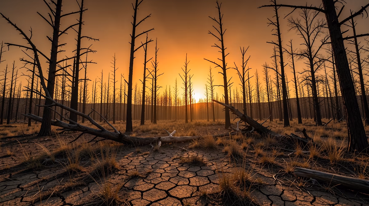
The current threat profile is the result of long-term environmental factors. The root cause lies in anthropogenic climate change, which has been severely exacerbated by multi-decadal mega-droughts. This environmental stress is compounded by the accumulation of flammable biomass resulting from a century of fire suppression policies and the rapid expansion of the wildland-urban interface.
Historically, the period between 1910 and 1970 saw a shift toward total fire suppression, which researchers now understand created a dangerous structural fuel debt in many Western forests. From 2000 to 2020, the onset of a chronic mega-drought transitioned these forests into a state of high susceptibility. Consequently, 2024 marks an era where the fire weather watch has become a near-permanent feature of the Western meteorological landscape. National Weather Service meteorologist Sarah Jenkins noted that the combination of high-velocity winds and dry fuel beds is a significant concern, emphasizing the need for the public to take these alerts seriously to prevent potential tragedy.
Political And Geopolitical Implications
The situation creates significant friction at the policy level. There is ongoing tension between federal land management agencies and state-level regulators regarding the allocation of funding for proactive measures like forest thinning versus the rising necessity of post-disaster insurance subsidies. Economically, the region is witnessing an insurance market collapse in high-risk zones, as well as a surge in disaster relief spending that devalues property assets.
Geopolitically, these conditions impact the security of global timber supply chains and highlight the strategic necessity of biomass management to prevent the massive carbon sequestration loss that complicates international climate accords. Furthermore, a hidden angle of this crisis involves the expansion of energy-grid infrastructure into high-risk zones, leading to complex debates over corporate liability shifting between utility companies and state regulators.
What Happens Next
Over the next 24 hours, National Weather Service offices will likely convert existing watches into red flag warnings as relative humidity drops and wind speeds intensify. Local jurisdictions are expected to implement more stringent burn bans and restrict outdoor activities in dry zones to prevent accidental ignitions.
Looking toward the next 72 hours, the peak of this weather event will align with critical conditions, followed by a gradual decrease in wind intensity. However, fuels will remain extremely dry and susceptible to ignition even after the winds subside. The best-case scenario involves a favorable shift in wind direction or increased humidity, preventing ignition and allowing for a silent downgrade of the watches. Conversely, the worst-case scenario involves significant new ignitions occurring at the height of the winds, which could overwhelm local initial attack resources and lead to large-scale evacuations and property loss.
Frequently Asked Questions
Q: What is a fire weather watch?
A: A fire weather watch is issued by the National Weather Service to alert fire officials and the public that dangerous wildfire conditions are possible. It indicates that dry conditions, low humidity, and high winds may combine in the coming 12 to 48 hours to create a high risk of rapid fire spread.
Q: What is the difference between a fire weather watch and a red flag warning?
A: A fire weather watch means that conditions favorable for fire growth are possible, while a red flag warning means those conditions are imminent or already occurring. Think of a watch as a heads-up to prepare, whereas a warning serves as a directive to take immediate action to prevent fires.
Q: What should you do during a fire weather watch?
A: During a fire weather watch, you should avoid any activities that could produce sparks, such as using power equipment outdoors or burning yard waste. It is also recommended to create a defensible space around your home and stay updated on local weather forecasts for any changes or upgrades to a warning.
Q: How long does a fire weather watch last?
A: A fire weather watch typically covers a specific window of 12 to 48 hours before the expected onset of critical fire weather conditions. If the conditions become more certain, the National Weather Service will upgrade the watch to a red flag warning.
Q: Why are fire weather watches issued?
A: These watches are issued to provide advanced notification to emergency responders and land managers so they can preposition resources. They also serve to warn the public about the heightened risk of wildfire ignition, helping to reduce human-caused fires during dangerous weather events.
Q: Does a fire weather watch mean there is a fire?
A: No, a fire weather watch does not mean a fire is currently burning. It simply means that the combination of wind, low relative humidity, and dry fuels has created an environment where any fire that starts would likely spread very rapidly and be difficult to contain.
Conclusion
The issuance of a fire weather watch across the Western United States serves as a critical indicator of the environmental challenges facing the region. While these watches do not confirm that a fire is burning, they underscore a heightened risk environment that demands vigilance from both policy makers and residents. As the 48-hour window progresses, the priority remains the prevention of ignitions and the maintenance of emergency preparedness. The combination of dry fuels and high winds creates a narrow margin for error, making the role of early, authoritative communication essential to protecting lives and infrastructure. Residents are encouraged to monitor updates from local weather stations and follow the guidance of emergency management agencies to navigate the coming days safely.
" }


.webp)
.webp)

.webp)
