.webp)
India Monsoon Patterns Reveal Structural Risks Beyond Heavy Rainfall
The rhythmic pulse of the Indian monsoon, once a predictable clockwork of agrarian prosperity, is transforming into a complex test of survival that challenges the very foundations of the nation's built environment. As the India Meteorological Department issues urgent red alerts across coastal districts, it has become clear that today weather India is more than a meteorological update—it is a critical indicator of a country struggling to reconcile its rapid urban expansion with the increasingly volatile reality of climate change.
The Current Weather Reality
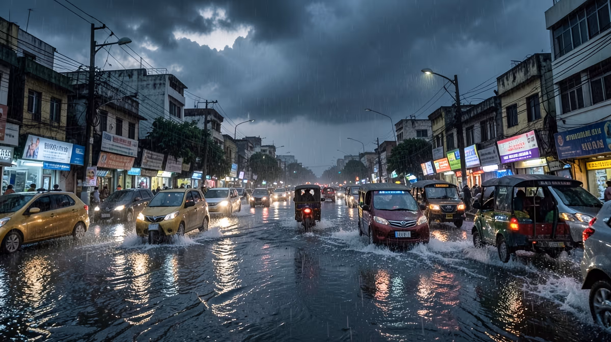
The India Meteorological Department has issued a red alert for heavy to extremely heavy rainfall across several coastal districts in Kerala and Karnataka as the Southwest Monsoon intensifies today, June 25, 2024. This active phase of the monsoon, driven by an offshore trough at mean sea level extending from south Gujarat to the Kerala coast, is fueling persistent weather activity across the Arabian Sea. The impact is immediate: localized flooding in low-lying areas of Kerala has disrupted essential transport services and forced the closure of educational institutions. Disaster response teams are on high alert, monitoring rising river levels while coastal fishing communities have been warned to stay away from the sea, where high-velocity winds reaching 50 kmph are expected.
Predicting the Next Three Days
Meteorological data suggests a dynamic shift in the coming 72 hours. In the immediate next 24 hours, heavy to very heavy rainfall is projected to batter Coastal Karnataka, Konkan, and Goa, with isolated but significant downpours likely in the Himalayan foothills. As the week progresses, the monsoon trough is expected to shift slightly northward. This movement will likely reduce precipitation intensity in the southern peninsula while simultaneously increasing rainfall activity across Northwest and Central India. Dr. Mrutyunjay Mohapatra, Director General of the IMD, has noted that the intensification of these currents is due to a favorable synoptic configuration, with systems being monitored continuously to ensure district authorities receive the most accurate data for public safety.
Infrastructure Under Pressure
The intersection of extreme weather and urban development has exposed systemic vulnerabilities in India’s infrastructure. The core issue lies in the historical divergence between infrastructure expansion and flood-plain topography. Throughout the 2010s, massive infrastructure projects were rolled out across the country, often ignoring the natural drainage patterns of urban centers. This legacy has left cities in the Indo-Gangetic plain and beyond highly susceptible to flash floods. Today, the challenge is shifting from mere expansion to climate adaptation. Policy makers and urban planners are under increasing pressure to prioritize climate resilience, moving away from short-term electoral populist schemes toward robust, long-term disaster management frameworks. The economic fallout is equally severe, with disruptions to the agricultural value chain threatening food inflation and increasing the financial burden on state-run crop protection insurance.
A Shifting Ecological and Geopolitical Landscape
The root cause of these erratic patterns is a combination of anthropogenic climate change and the cyclical influence of the El Niño-Southern Oscillation. These environmental shifts do not exist in a vacuum; they carry profound geopolitical weight. Transboundary water management is becoming increasingly complex, as erratic monsoon rains complicate long-standing agreements like the Indus Waters Treaty, potentially straining relations between regional neighbors. Moreover, the human cost is mounting. A silent crisis is brewing as climate refugees migrate from rural hinterlands to already overburdened urban slums, seeking safety from the failure of traditional agricultural cycles. This migration creates long-term socio-economic instability and places an unprecedented strain on municipal services.
Expert Outlook and Scenarios
Experts warn that the prevailing monsoon circulation suggests a wet week for the northern plains, with a significant potential for localized urban flooding caused by heavy bursts of convection. In a best-case scenario, the monsoon remains well-distributed, supporting Kharif crop sowing across the agricultural belt without causing structural damage. However, the worst-case scenario involves intense, localized cloudburst events in the Himalayan region, which could trigger catastrophic landslides and flash floods, potentially coinciding with river breaches in the Indo-Gangetic plains. The task for authorities is to balance these risks through proactive planning, utilizing early warning systems provided by the Ministry of Earth Sciences and the National Disaster Management Authority to mitigate the potential for humanitarian disaster.
Frequently Asked Questions
What is the best weather app for India?
The IMD Weather app and AccuWeather are widely considered the most reliable for Indian weather conditions. These apps provide localized forecasts, severe weather alerts, and real-time data specific to various Indian cities and regions.
How is the weather in India throughout the year?
India experiences diverse weather patterns including a hot summer from March to June, a monsoon season from June to September, and a pleasant winter from November to February. These patterns vary significantly across the northern mountainous regions, the central plains, and the southern coastal areas.
When does the monsoon season start in India?
The monsoon season typically arrives in India in early June, starting with the coast of Kerala. It gradually progresses across the entire country, bringing the majority of India's annual rainfall between June and September.
Which are the coldest months in India?
December and January are generally the coldest months in India, especially in the northern states where temperatures can drop significantly. During this period, some high-altitude regions in the Himalayas experience heavy snowfall while the rest of the country enjoys cool, dry weather.
How do I check live weather alerts for my city?
You can check live weather alerts through the India Meteorological Department (IMD) website or by using integrated weather services on platforms like Google Search. Simply searching for the city name followed by weather will display current alerts, warnings, and hourly forecasts provided by official meteorological sources.
Why is the weather in India so hot in May?
The high temperatures in May are caused by the sun's position directly over the Tropic of Cancer, leading to intense solar radiation across the Indian subcontinent. Additionally, the pre-monsoon dry winds contribute to the extreme heat conditions experienced before the arrival of the cooling rain-bearing monsoon currents.
Conclusion
The intensification of the Southwest Monsoon serves as a reminder of the fragility of current infrastructure in the face of environmental change. While immediate efforts are focused on disaster response in the coastal districts of Kerala and Karnataka, the broader, long-term requirement remains a fundamental redesign of how India plans for climate resilience. As the monsoon progresses toward Northwest and Central India, the coordination between the India Meteorological Department, disaster management authorities, and local government bodies will determine the nation's success in managing the physical and economic risks of this season. Future developments will rely on the integration of better drainage, sustainable urban planning, and a more adaptive policy framework to handle the challenges of an increasingly volatile climate.


.webp)
.webp)

.webp)
